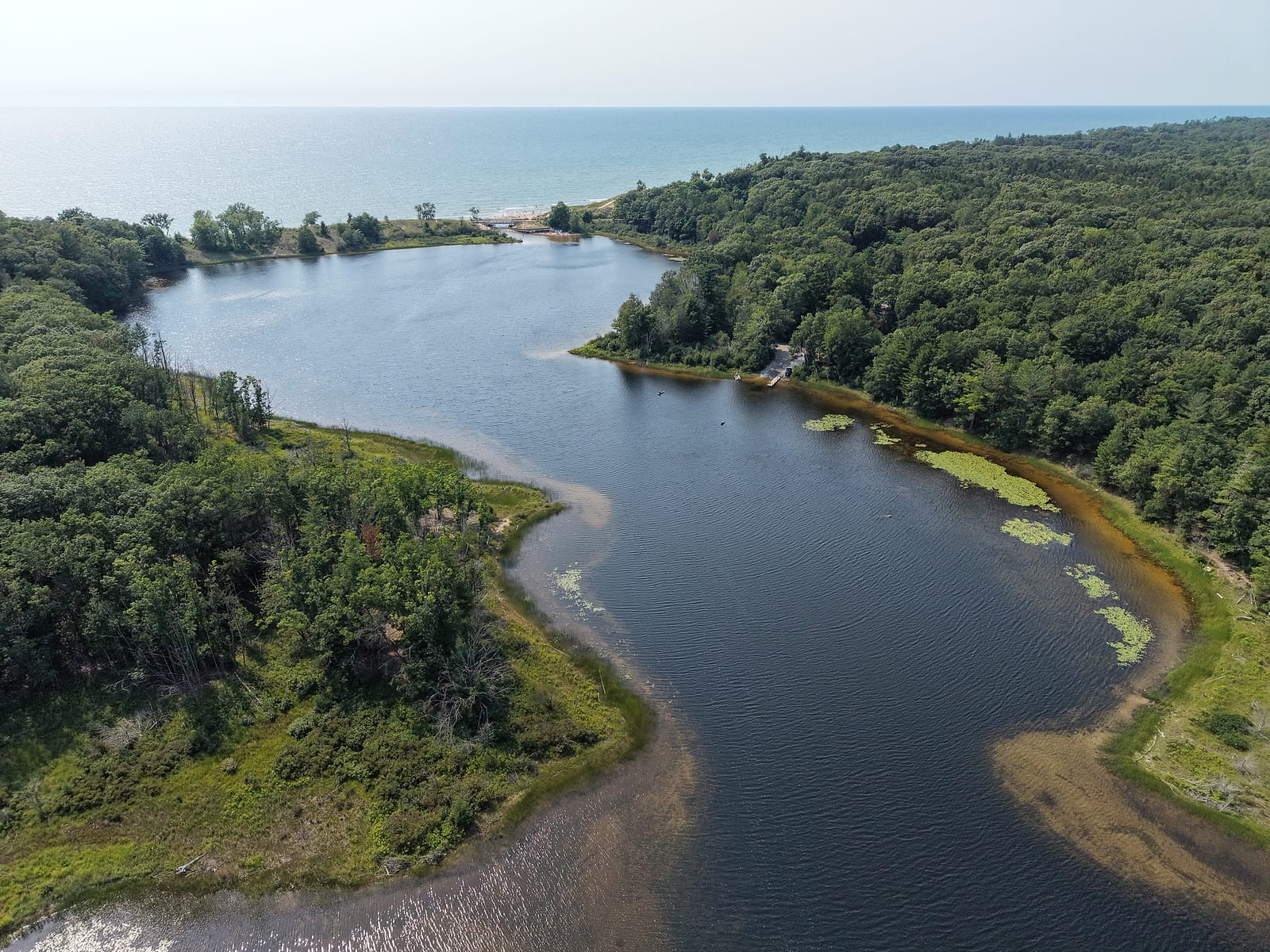
Duck Lake, Muskegon County: Quiet Lakefront Living Beside the State Park
Last reviewed August 2026. Park rules, water conditions, and access details change - use the linked sources on this page to check current information before relying on it.
Duck Lake is the quietest water this site covers: about 271 acres in Fruitland Township, a short drive up Scenic Drive from North Muskegon, with Duck Lake State Park wrapped around its north shore and outlet. This is the Duck Lake in Muskegon County - the one at the state park, with a Whitehall mailing address and the big lake at its doorstep - not the larger Duck Lake at Interlochen, and not the one near Albion. GVSU's Annis Water Resources Institute classifies it as a drowned river mouth lake: Duck Creek and Scholes Creek feed it, a wetland complex spreads across its east end, and a narrow, shallow channel lets it out into Lake Michigan at the park.
The character follows from that geography. The state owns the wooded dunes on the north side, homes hold the south shore and the Scenic Drive corridor, and the outlet corner draws beach families all summer. There is no bar to boat to, no marina, and no route to the big lake for anything with a motor. What Duck Lake offers instead is calm water with a state park for a neighbor, and one of the area's favorite beaches where its stream crosses the sand.
Quick Facts
- Lake Size
- About 271 acres (GVSU/AWRI)
- Lake Type
- Drowned river mouth, wetland east end
- Connected To
- Lake Michigan - shallow, non-navigable outlet
- Main Inflows
- Duck Creek and Scholes Creek
- Township
- Fruitland Township, Muskegon County
- Public Access
- State park launch, Recreation Passport entry
- Boating
- Motorboats allowed; west end slow-no-wake
- Fishing
- Open all year under drowned-river-mouth rules
- Best For
- Still water, paddlers, park-side living
The Channel That Boats Cannot Use
Everyone local calls the outlet "the channel," and it is worth being precise about what that means here, because on this site the word usually comes with boats attached. The DNR's park page describes "a shallow channel connecting the two" lakes; Fruitland Township's master plan calls it a non-navigable controlled outlet, and the township owns the small water-level structure that keeps the lake where it belongs. That structure has a name and a number: EGLE's dam inventory lists it as the Duck Lake Level Control Structure, holding the lake to a court-set summer level of 579.8 feet under a 2004 order. In practice the channel is a stream sliding under the Scenic Drive bridge, with a park boardwalk running beneath the road so you can walk from the Duck Lake side to the Lake Michigan beach without crossing traffic. On Mona Lake, the channel question is which boats fit through. Here the answer is none - nothing gets through, not even a kayak. The outlet belongs to feet and floats.
That is exactly why families love it. The lagoon where the lake narrows toward the bridge is warm, shallow, and calm - small kids float it, waders walk it, and the state park rents kayaks a short carry away. The park's boat launch serves the lake proper, with its parking lot reserved for vehicles with boat trailers under a park-specific state land use order, and a 1970 watercraft control keeps everything west of the Lamos Road line at slow-no-wake, which is most of the water a swimmer or paddler will ever touch.
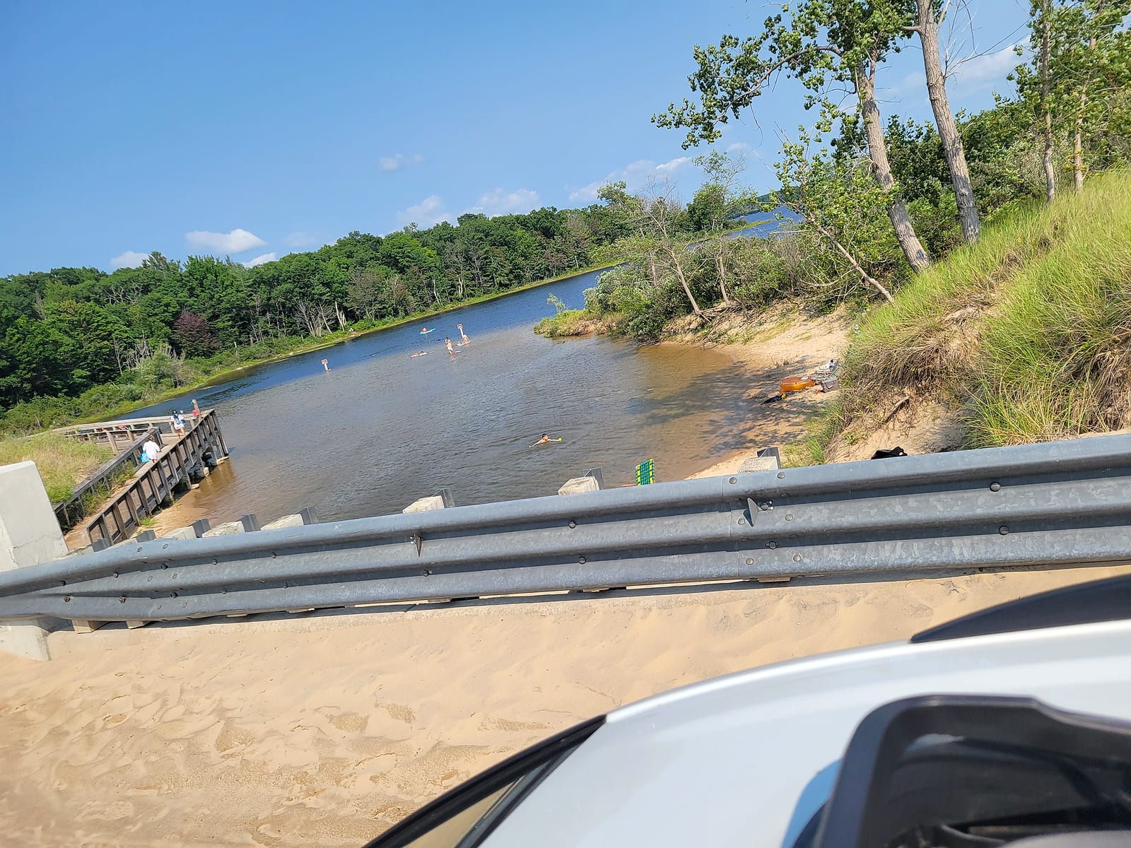
The lagoon on the Duck Lake side of the bridge, from the Scenic Drive guardrail: warm, waist-deep water, the park boardwalk at the left, and floaters drifting on a July afternoon. July 2026.
The Beach and the Wandering Stream
On the far side of the bridge, the stream finishes its run across a clean, sandy Lake Michigan beach - Travel Michigan counts half a mile of shoreline here, backed by a towering dune. The mouth never sits still. Sandbars move it, storms redraw it, and every visit the stream has found a slightly different path to the big lake. That is my observation from years of family beach days here, not something any agency publishes: kids treat the shifting stream as the best part, parents set umbrellas on the sand beside it, and the walk out along the braided water is a little different every time.
Go in knowing the ground rules, which the park posts plainly: no glass containers, no ground fires, park closes at 10 p.m., and no beach guard on duty. The DNR says it in its own words for every state park - there are no beach guards, and visitors swim at their own risk. On a calm day the shallows here are as friendly as Lake Michigan gets; on a wind, the flags and the waves tell you what kind of day it is. The Lake Michigan shoreline guide covers the open-coast habits that apply to this beach as much as any other.
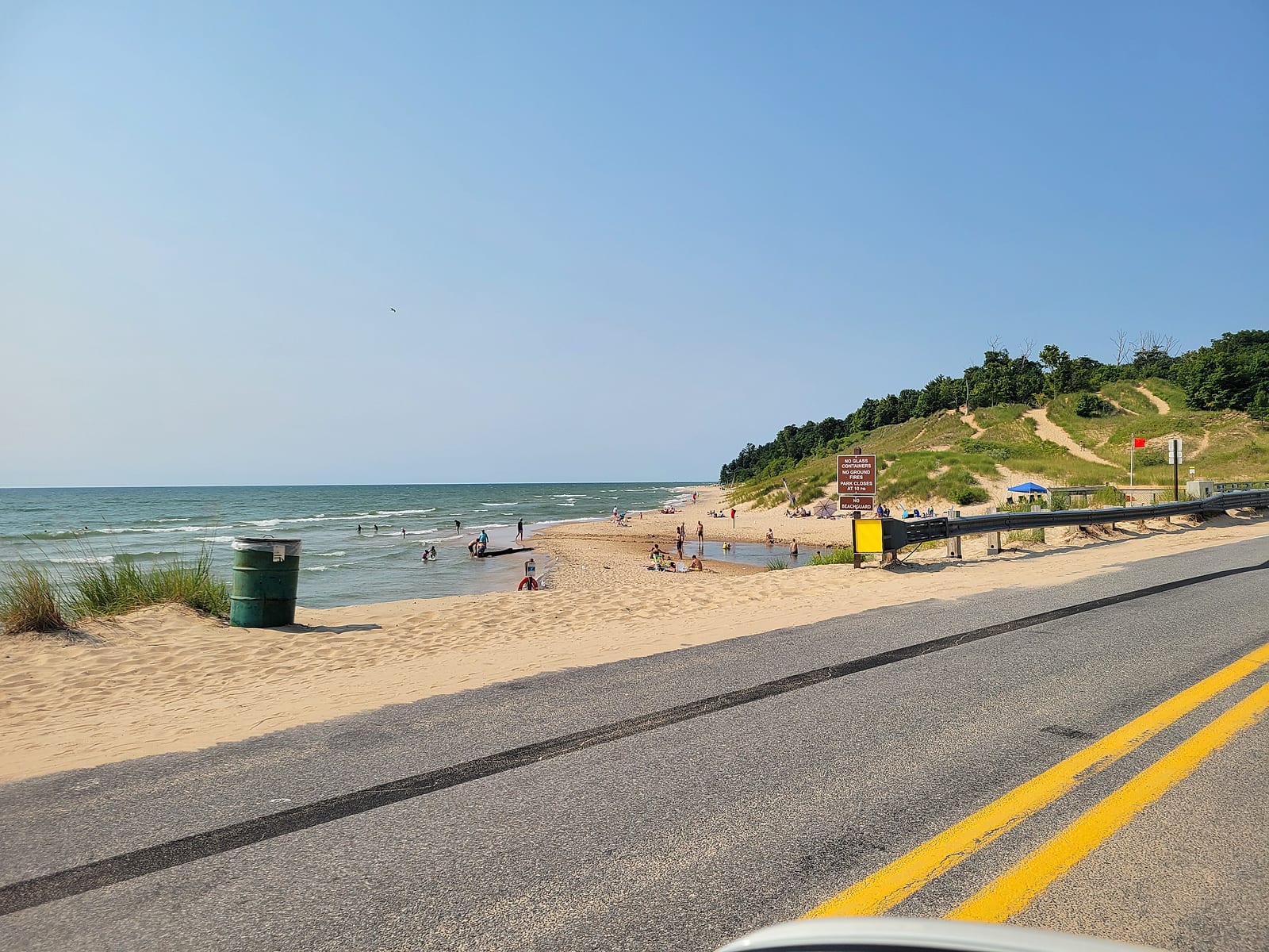
The stream crossing the beach to Lake Michigan on a red-flag afternoon, with the dune ridge behind and the park's posted rules on the sign: no glass, no ground fires, park closes at 10 p.m., no beach guard. July 2026.
The Lake Itself
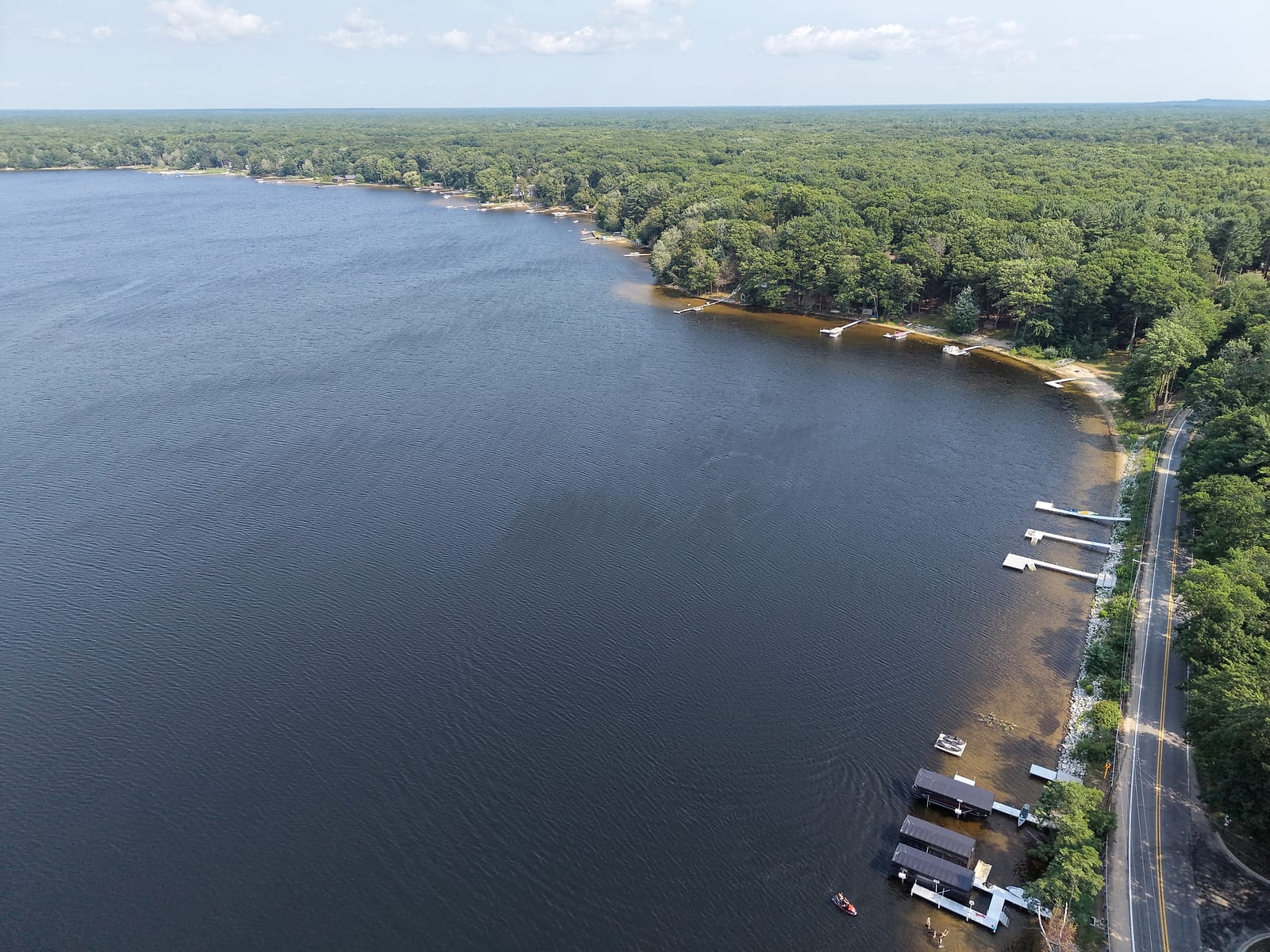
Stand at the outlet and look east and the lake runs away from you in one long, wooded reach: dark, clean-looking water, the state's dunes and forest on the north side, cottages and docks threading the south shore. The DNR's park boundary data puts about 739 acres of state land here, and the park's own map shows that land wrapping the entire north shore of the lake. By my read, half or more of the shoreline is parkland - that share is my estimate, but the maps make the shape of it plain. For a lakefront buyer, that is the rare arrangement where the land across the water is parkland, not a future subdivision.
That arrangement has a history. For about fifty years the north shore belonged to the Boy Scouts, and a White Lake Beacon history of the camps traces it: a Chicago council bought a hundred acres at the outlet from Carrie Mears in 1920 and built Camp Wabaningo, then sold ground nearby to a Grand Rapids council, which opened Camp Shawondossee in 1927 or 1928. One of Shawondossee's first staff members was a young Gerald Ford, a year past the Eagle Scout rank he had earned at fourteen - his presidential museum's Growing Up Grand exhibit documents those camp summers. The councils sold to the Nature Conservancy in the early 1970s, the state took the land in 1974, and in 1988 it opened as the day-use park across the water.
How deep is it? Honestly: no official number exists. The DNR has no contour map or fishery survey on record for this Duck Lake - the Duck Lake depth charts you find online belong to the ones in Grand Traverse, Calhoun, and Allegan counties - and the aggregator sites that quote depths for this lake disagree with each other. One measured anchor exists: trained volunteers have sampled this lake for the state's Cooperative Lakes Monitoring Program since at least 2013, and the program logs their sampling site at 60 feet deep, with temperature profiles reaching 65 feet. The same data puts numbers to the water itself - summer 2025 clarity readings ran 8 to 13 feet, and phosphorus tests since fall 2023 have come in between 9 and 15 parts per billion. What the official record does establish is the fishing: the DNR's current fisheries order treats Duck Lake as a drowned river-mouth lake, open to fishing the entire year, from its mouth up to the Nestrom Road limit. The wetland east end where Duck Creek comes in is the fish-and-bird end; the west half is the living room.
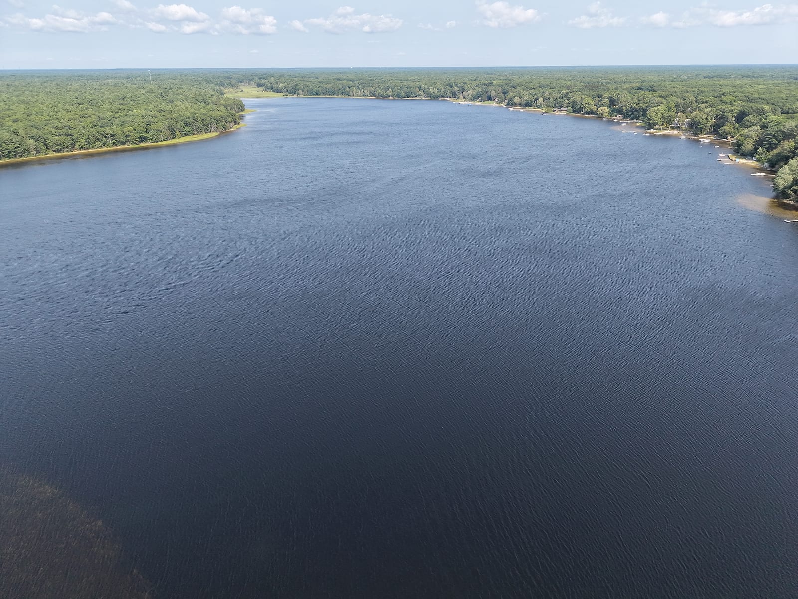
Looking east down the length of the lake from above the outlet end: park forest to the left, the home shore to the right, and the wetland reach in the far distance. July 2026.
Scenic Drive and the Dune-Top Arrangement
Scenic Drive is the spine of this corridor, and along the lake's west and south edges it runs close enough to the water that docks and boathouses sit directly off the road shoulder. The signature arrangement here is one you will not find on the bigger lakes: homes up on the dune with Lake Michigan views keep their docks down on Duck Lake. Big-lake sunsets from the deck, small-lake boating from the dock, and the beach a walk away - that combination is the corridor's whole pitch, and it explains why the homes hold their owners. Places on this lake do not come up often, and when they do, they move quickly - my observation from watching this corridor, not a market statistic.
The same stretch of Scenic Drive is the locals' sunset seat. Where the road rides beside the Lake Michigan dunes north and south of the park, you can pull over, park next to the sand, and watch the sun go down over the water without leaving the driver's seat - or cross the beach for a swim first. On a clear July evening the shoulder fills up, and everyone faces west.
One caution before you fall for a specific address here: a small, creek-fed lake with a controlled outlet and low ground at its east end behaves differently in wet years than a sunny showing suggests. The Muskegon waterfront flooding and hidden-risks guide walks through checking an exact parcel for flood and high-water exposure - the homework that applies on Duck Lake the same as everywhere else on this coast.
Is Duck Lake Right for You?
Duck Lake suits people who want Muskegon-area lake life at its smallest and slowest: paddlers, anglers who like a year-round season, families who measure a lake by its beach, and buyers drawn to a shoreline where the state owns the far side. The trade is real - no channel run to Lake Michigan, no boat-up dinner, and a small lake that a serious wake boat outgrows fast. If those are the things you want, Muskegon Lake is the answer. If what you want is calm water, a state park for a neighbor, and the big lake a boardwalk away, this corridor is hard to beat.
Common Questions About Duck Lake
Where is Duck Lake?
Duck Lake sits in Fruitland Township in Muskegon County, on Scenic Drive between North Muskegon and White Lake, with a Whitehall mailing address at the state park. It is a short drive up the shoreline from Muskegon, and Duck Lake State Park wraps its north side where the lake meets Lake Michigan.
How big and how deep is Duck Lake?
GVSU's Annis Water Resources Institute puts Duck Lake at 271 acres, a drowned river mouth lake fed by Duck Creek and Scholes Creek. Depth is a different story: no official number exists. There is no DNR contour map or fishery survey for this Duck Lake, and the depth figures on aggregator lake sites disagree with each other. The nearest thing to a measured depth comes from the state's volunteer monitoring program, which has sampled the lake for years and logs its site at 60 feet. Treat any other depth you read for this lake as unsourced.
Can you boat from Duck Lake to Lake Michigan?
No. The outlet at the state park is what Fruitland Township's own master plan calls a non-navigable controlled outlet - a shallow stream passing under the Scenic Drive bridge and across the beach. You can paddle the lake and float the warm lagoon by the bridge, but no boat runs through to the big lake. If channel access to Lake Michigan is the point, that is Muskegon Lake's territory, or White Lake's.
Is there camping at Duck Lake State Park?
No. It is a day-use park, open 8 a.m. to 10 p.m. like Michigan's other day-use state park areas, with a Recreation Passport required for vehicle entry. The nearest state-park camping is at Muskegon State Park to the south.
What are the boating rules on Duck Lake?
It is open to motorboats, with one long-standing state watercraft control: everything west of a line 800 feet west of Lamos Road is slow-no-wake, a rule on the books since 1970. That covers the west end toward the park and the outlet, which is also where the swimmers and paddlers concentrate.
Is swimming at the Duck Lake channel safe?
It is one of the most popular family swim spots in the area - a warm, shallow lagoon on the lake side and the stream across the beach on the Lake Michigan side. Go in knowing the setup: the DNR notes there are no beach guards at state parks, so swimming is at your own risk, and Lake Michigan conditions change with the wind. Watch the posted flags and signs on the day.
Sources
- Michigan DNR: Duck Lake State Park - day-use park, channel, boardwalk, launch, Recreation Passport
- DNR park map (PDF) - park land along the north shore, beaches on both waters
- GVSU Annis Water Resources Institute: Duck Creek watershed report (PDF) - 271 acres, drowned river mouth, tributaries
- Fruitland Township Master Plan (PDF) - non-navigable controlled outlet, shoreline development pattern
- Fruitland Township Parks & Recreation Master Plan 2022 (PDF) - lake and channel description
- EGLE Michigan Dam Inventory - Duck Lake Level Control Structure: township-owned, court-set summer level 579.8 feet (2004)
- MiCorps CLMP data portal: Duck Lake station 610778 - volunteer monitoring records; sampling-site depth, clarity, and phosphorus
- DNR Fisheries Order FO-254.25 (PDF) - drowned river-mouth lake, year-round fishing, Nestrom Road limit
- DNR local watercraft controls, Muskegon County - the 1970 west-end slow-no-wake rule
- DNR state park rules - day-use hours 8 a.m. to 10 p.m.
- DNR Land Use Orders of the Director, Chapter V (PDF) - the boat-launch parking rule at Duck Lake State Park
- DNR beach safety - no beach guards at state parks; swim at your own risk
- White Lake Beacon: "Duck Lake has scouting past" (2008) - Camp Wabaningo, Camp Shawondossee, the Mears purchase, and the Conservancy-to-state chain
- Gerald R. Ford Presidential Museum: Growing Up Grand - Ford's Camp Shawondossee summers and his Eagle Scout rank at fourteen
- Travel Michigan: Duck Lake State Park - half a mile of Lake Michigan shoreline
Related Areas
Mona Lake
The southern counterpart: another small lake with a channel story, though that one lets smaller boats through.
Read the Mona Lake guideWhite Lake
The next lake north on Scenic Drive, with a real navigable channel, two towns, and a working marina scene.
Read the White Lake guideLake Michigan Shoreline
The open-coast tradeoffs behind every beach on this page: waves, sand, erosion, and the forecast habit.
Read the Lake Michigan guideNorth Muskegon
The nearest town heading south, elevated over Muskegon Lake, with schools, parks, and everyday services.
Read the North Muskegon guideAbout this guide
Written by James Maurer, a retired municipal employee with 25 years in West Michigan local government and a lifetime on these lakes.