Muskegon Waterfront Flooding and Hidden Risks Buyers Should Know
The view sells the house. The water level on a calm July afternoon sells the house. What a listing almost never shows you is the property on a high-water day with a hard west wind, or the line in the basement where the water stopped last spring. That is the part worth understanding before you buy.
This page is about the quiet risks that do not appear in a listing photo and that a seller is not eager to volunteer: flooding and high water, shoreline erosion, dock and seawall limits, and the building problems that hide inside some waterfront condos. The difference between a good waterfront purchase and an expensive one usually comes down to knowing the specific address, not the lake on the sign.
If you are still comparing areas, start with the area guides: Muskegon Lake, Bear Lake North Muskegon, Lake Michigan shoreline, North Muskegon, and waterfront condos. Then use this page as a reality check before you fall for a view.
Flooding and High Water Are Real on the Muskegon Waterfront
Muskegon Lake is calmer than the open big lake, but it is not sealed off from it. The channel ties Muskegon Lake directly to Lake Michigan, so when the Great Lakes run through a high-water cycle and a strong west or northwest wind pushes water back east, the low-lying lakefront feels it. In recent high-water years, local news has repeatedly documented water being pushed into homes on the Muskegon Lake side. Some owners have run sump pumps straight through the winter when they used to shut them off, and flood insurance has covered only a fraction of the repair cost.
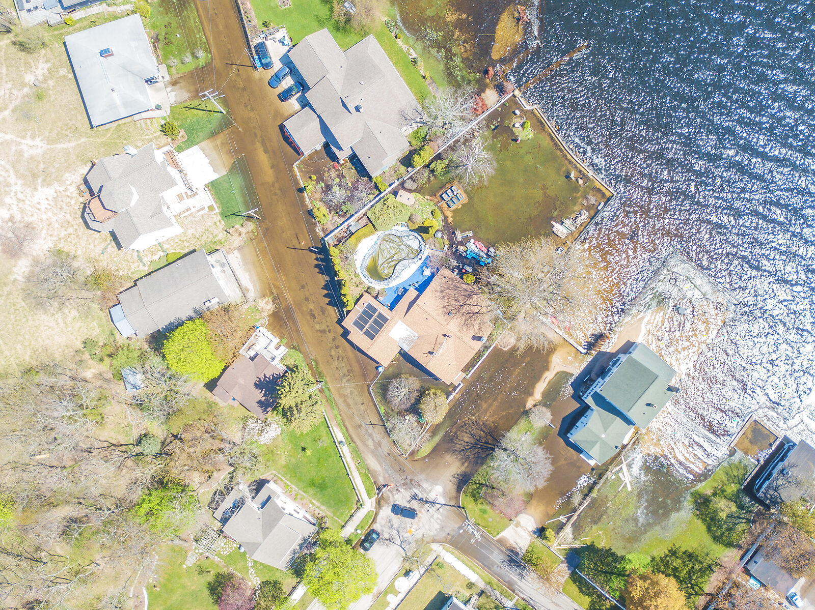
Drive those same streets on a calm summer day and you would never guess. The lawns are green, the seawalls are dry, and the listing photos look perfect. High water leaves no mark you can see from the curb, which is exactly why it is so easy to buy into a problem without knowing it is there. The most dependable way to learn which specific parcels have a history like this is from someone who was here and remembers it.
The flooding is confined to specific low-lying streets and parcels. Two homes a block apart can have completely different high-water stories, which is why the general impressions "Muskegon Lake floods" and "Muskegon Lake is fine" are both useless. You want the history of the exact address.
River-adjacent property is a separate question. The Muskegon River upstream can reach major flood stage in a wet spring; in April 2026, rising water below Croton Dam prompted evacuations in the Newaygo County floodplain. That is well upriver from the lakefront, but it is a reminder that "waterfront" near Muskegon can mean lake exposure, river floodplain, or both, and they carry different risks.
How to Actually Check Flood Risk for an Address
Do not guess from how high the lot looks on a dry day. Check it properly, and check the exact parcel, not the street:
- FEMA flood map: Enter the address in the FEMA Flood Map Service Center to see the mapped flood zone. The zone affects insurance requirements and lending.
- City of Muskegon floodplain information: The City of Muskegon Flood Plains page explains local floodplain rules and permitting.
- Michigan EGLE mapping: The state's floodplain mapping is another official reference.
- Forward-looking risk: A service like First Street's flood risk report estimates risk beyond the static FEMA maps, which can lag real conditions.
- The seller and neighbors: Ask directly about past flooding, sump-pump history, basement water, and insurance claims. Then ask a neighbor who has been there a while; they will often tell you what a disclosure form will not.
- Insurance reality: Get a flood insurance quote before you are committed. A high premium, or a claim history that follows the property, tells you something the asking price does not. Do not read the seller's current premium as your future bill, either: FEMA's current pricing approach rates each policy to the property's own flood risk, with statutory limits capping most annual increases at 18% - so a long-held policy can sit below its full-risk price. If the seller's policy carries a discount, ask about taking the policy over: FEMA allows a policyholder to transfer the discount by assigning the policy to the new owner at the sale.
If your honest reaction to that list is "there is no way I am doing all of that," you are not wrong, and there is a shortcut. Most of it already lives in the head of someone who has watched these shorelines and buildings for years: the flooded streets, the lots that drain badly, the buildings with a history. Local knowledge built over decades does in one conversation what a weekend of map-reading only approximates. The real trick is finding the person who actually has it and is willing to share it. Plenty of people know which addresses have trouble; not all of them have a reason to tell you before the sale closes.
A Flood Map Is Not a Full Risk History
It is easy to treat a FEMA flood zone as the final word, and for one purpose it nearly is: the zone decides whether a lender requires flood insurance at all. What the policy costs works differently - since 2023, FEMA prices each policy to the property itself, weighing flood frequency, flood types, distance to the water, elevation, and rebuild cost rather than the zone alone. But the map answers one narrow question - is this parcel inside a mapped 1%-annual-chance floodplain - and that is not the same as the property's real water history. A home can sit just outside the mapped zone and still have taken on water in a high-lake year, because the maps are built from modeling and past data, not from what the wind did to Muskegon Lake last spring.
Plenty of expensive water problems live entirely outside the flood-zone question:
- Wind-driven high water: a hard west or northwest wind in a high-lake year pushes water onto low-lying streets a static map may never flag.
- Groundwater and drainage: a high water table, a lot that drains badly, or a failed neighborhood storm drain can put water in a basement that no flood zone covers.
- Sump-pump and seepage history: a pump that now runs all winter, or a basement that has already seen water, is parcel history, not zone data.
- Shoreline and bluff erosion: losing ground at the water is a different hazard from inundation, and the flood map does not track it.
- Condo water claims and assessments: a building's repeated water-damage history shows up in HOA records, never on a FEMA panel.
So use the flood map for what it is good at - the insurance requirement and lending - and then go get the rest of the story from the seller's disclosures, the neighbors, the condo documents, and anyone with a long memory of the specific shoreline. The zone tells you what a lender will require. The history tells you how the property actually behaves.
The Problems a Listing Will Not Mention
Flooding is the headline risk, but it is not the only one that stays off the listing sheet. A few that matter around here:
Shoreline and Bluff Erosion
On the Lake Michigan side especially, high-water years have eaten into bluffs and dunes and undermined stairs and decks. Ask for the erosion history, look for cracked or leaning shore structures, and find out whether any existing seawall, revetment, or riprap was actually permitted. Unpermitted shore protection can become the new owner's legal and financial problem.
Dock, Seawall, and Channel Limits
What you can build or keep at the water is not automatic. Dock size, seawall work, and shoreline alteration can require permits through Michigan EGLE and local review, and on Bear Lake the bridge clearance limits boat size regardless of what the lot looks like. A property that cannot legally hold the dock or boat you pictured is a different property than the one you thought you were buying.
Condo Building Systems and Assessments
Waterfront condos carry a risk that single-family buyers do not: a problem in one building can become every owner's bill. Some waterfront condo buildings in the area have had repeated water-damage events from failed building systems, such as fire-suppression or plumbing lines letting go and flooding multiple units at once. The HOA will not lead with that, and the seller's side may not know it or may not say. The damage shows up later as special assessments, rising dues, or an insurance deductible spread across the association.
You can protect yourself with the documents. Before buying a waterfront condo, request the HOA meeting minutes for the last few years, the reserve study, the insurance claim history, and any record of past or planned special assessments. The deeper condo-document walkthrough is on the waterfront condo buyer checklist; read it before you sign anything.
Water, Septic, and Seasonal Access
Some waterfront parcels run on a private well or septic system rather than municipal service, which changes maintenance and inspection. Others sit on private or shared roads that are quiet in July and a plowing question in February. Each of these is manageable, and each is far better learned before closing than after.
Nothing forces that learning at the sale, either. Muskegon County's sanitary code has no septic or well inspection requirement at a property transfer - its permits attach to construction and repair, not to closings - so an evaluation of the system you are buying happens only if someone orders one. The county health department performs them for a posted fee and notes itself that lenders are the ones who usually ask. On older lakefront parcels it is money well spent: the same code will not permit a new drainfield within 400 feet of a lake where the seasonal high water table comes within 48 inches of the bottom of the system, unless approved site modifications make up the difference. That is a rule about exactly the ground a lakefront system sits in - and it means an aging system on a small waterfront lot may have no easy replacement path if it fails.
Wells carry their own homework. The county performs well evaluations too, with water sampling worth adding on a lakeshore lot, and one code provision is written for exactly the cottage situation: a water supply that has sat unused for more than a year cannot legally go back into service until it is shown to meet the code. If the place you are buying spent its life as a summer cottage, the well, the septic system, and the road that reaches them were all built around part-time use. Find out how they handle a full-time household before the closing, not the first winter after it.
The Internet the Parcel Gets
Internet service follows the same logic as the sewer line: what an address can get depends on which wires already reach it, and the house itself will not tell you. In town, several wired providers usually compete for the same block. On the wooded roads out by the smaller lakes, the cable can stop short of the driveway, and the fast connection a buyer assumed turns out to be a satellite dish. Anyone planning to work from home should learn which kind of address they are buying before the offer, not at the first frozen video call.
There is a two-minute check. Every provider must file with the FCC, location by location, where it offers service, and the FCC publishes those filings as a public map. Here is what that map reports for two addresses in Muskegon County, pulled the same day:
What the Federal Broadband Map Shows at Two Addresses
One has eight providers competing for it. The other has three satellite companies and no wire. Same county. The difference is where the cable already ran.
Wooded address near Twin Lake
Not Served 3 residential providers
| Provider | Technology | Down | Up |
|---|---|---|---|
| HughesNet | GSO Satellite | 100 | 5 |
| Starlink | NGSO Satellite | 280 | 30 |
| Viasat | GSO Satellite | 100 | 3 |
No wired provider reported at this location. Satellite is the whole list.
In-town address, Muskegon
Served 8 residential providers
| Provider | Technology | Down | Up |
|---|---|---|---|
| AT&T | Licensed Fixed Wireless | 100 | 20 |
| Frontier | Fiber to the Premises | 7,000 | 7,000 |
| HughesNet | GSO Satellite | 100 | 5 |
| Starlink | NGSO Satellite | 280 | 30 |
| T-Mobile | Licensed Fixed Wireless | 100 | 20 |
| Verizon | Licensed Fixed Wireless | 300 | 20 |
| Viasat | GSO Satellite | 100 | 3 |
| Xfinity | Cable | 1,200 | 35 |
Speeds in Mbps, as reported by each provider.
Sending 5 GB of photos, at the speeds each provider reports: about 22 minutes by satellite, about 6 seconds by fiber.
Providers file this twice a year and nobody measured it at the house. Use it to narrow the list, then make the seller and the provider confirm what is installed.
A big sale price does not shortcut the check. I ran one recent local million-dollar sale through the same lookup, and the wired options came back as cable and a copper phone line reported at 10 down, 1 up. No fiber is listed at that address. Its fastest reported upload, on the cable, is 35 Mbps.
The map gets you to a short list; the house settles it. Before you close: ask the seller what service is installed today and what it runs per month, have them start a speed test you can watch at the showing, and call the provider to confirm it will serve that address at the quoted speed. A wooded lot served only by satellite can still be the right buy. The point is knowing the internet you are getting the day you sign, the same way you know the well and the septic.
Coming Costs the Municipality Has Not Billed Yet
Some of the most expensive surprises come from decisions a local government has made, or is about to make, that simply have not turned into a bill yet. A city or township may be planning to extend municipal water or sewer to parcels now on wells or septic - and for sewer, the obligation is already written down: under Muskegon County's sanitary code, once a public sewer reaches the road a parcel fronts and passes within 200 feet of the building, connection is mandatory within 18 months. The project arriving on your street is a connection charge, and often a special assessment spread over years, already heading your way. A road, sidewalk, or drain-district project can be assessed to the owners along it. A new millage can be heading to the next ballot. None of this shows on a listing, because none of it is a current cost yet; it is a planned one.
The information exists, but you have to go looking for it: ask the city or township clerk and the assessor about planned special assessments, mandatory connection ordinances, and pending infrastructure projects, and read the recent council or board minutes and any capital improvement plan. Someone who follows the local agenda often knows what is coming well before it is posted. For how these costs and millage differences play out by area, see the Muskegon waterfront property tax comparison.
Who Controls the Lake Level - and Who Pays
There is a question that rarely comes up before a purchase and can surface with a bill attached afterward: who decides how high the lake sits, and who pays for whatever controls it? Michigan's inland-lake-level law - Part 307 of the Natural Resources and Environmental Protection Act - lets a county board, on its own motion or a petition of two-thirds of the lakefront owners, ask the circuit court to set a legal lake level, and the cost of establishing and maintaining that level can then be assessed to the properties that benefit. On some Michigan lakes, the water level is a court order with a tax roll attached.
Around here the answer is simpler than in most of inland Michigan, and still worth knowing. Muskegon Lake, Bear Lake, Mona Lake, and White Lake all connect to Lake Michigan through open channels, so they ride the big lake's level - no court-set level, no control structure, which is why the high-water years reached the yards in the photo above. Duck Lake is the local exception: a 2004 court order set its summer level at 579.8 feet, with Fruitland Township as the delegated authority in charge of the controlled outlet. And the level is not the only thing a lake can bill for - Bear Lake's lake board funds its plant-control work through a special assessment district. Whichever lake you are buying on, ask at the township or city hall whether the parcel sits in any lake-related assessment district before you count on the tax bill you were shown.
The Water Problems Only Locals Remember
A house lists on a quiet creek or channel arm. The inspection passes - a home inspection inspects the house, not the waterway. Nobody in the transaction mentions what neighbors have known for years: that stretch of water carries a sheen after a hard rain, or took a contamination hit decades ago that never made a listing.
You close, you discover it the first wet spring, and your options at that point are limited, slow, and expensive. The seller's side may genuinely not have known either; the inspection was never going to say.
The protection is homework done before you buy, especially on creek-fed water: look up the area in EGLE's public cleanup and monitoring records, ask the lake association what the water does after heavy rain, and put the question to whoever has lived on that stretch the longest. A local agent who has lived around this water would likely know it - an out-of-area agent can easily miss it. History like this lives in local memory, not in listings.
Rental Rules That Cancel the Income Plan
A listing that mentions Airbnb income is selling you something that may not survive the closing. In the City of Muskegon, short-term rental licenses are non-transferable and capped by neighborhood; in North Muskegon, zoning prohibits short-term rentals on most residential waterfront streets outright. If rental income is part of your math, the Muskegon short-term rental rules guide breaks down what each city actually allows, and what to verify before you count on it.
A Listing Sells the View. Local Knowledge Catches the Rest.
Which streets took on water last spring, which bluff is losing ground, which creek carried a sheen after hard rain, which condo building has had repeated water damage: that is not in a listing, and it is rarely in a disclosure. Whoever helps you buy should already carry that map in their head.
What This Means If You Are Buying
The Muskegon waterfront rewards the buyer who does this homework on the specific property and leans on people and records that know the local history. Where to go next:
- Working through the practical side of relocating? Use the Muskegon waterfront relocation checklist.
- Looking at a condo? The condo buyer checklist covers the documents that surface the risks above.
- Comparing tax exposure by area? See the property tax comparison guide.
- Unsure what the listing terms even mean? Read lakefront vs waterfront in Muskegon.
- Buying on Bear Lake? Check the Bear Lake water quality guide for algae and seasonal conditions.
- Boating depth and channels? The Muskegon Lake and Bear Lake water depth map is a useful orientation reference.
Common Questions
Does Muskegon Lake flood?
Yes, in spots. Muskegon Lake connects to Lake Michigan through the channel, so when lake levels run high and a sustained blow out of the west or northwest stacks water toward the east end, low-lying lakefront streets can take on water. Local news has documented homes flooding on the Muskegon Lake side during high-water years, and in some of those homes the sump pump kept going through the cold months. It is very location-specific, which is exactly why you check the precise address, not the lake name.
How do I check if a Muskegon waterfront property is in a flood zone?
Start with the FEMA Flood Map Service Center and enter the exact address; it shows the mapped flood zone. The City of Muskegon also publishes floodplain information, and Michigan EGLE maintains statewide floodplain mapping. For a forward-looking view, First Street's risk report estimates flood risk beyond the FEMA maps. Do not judge flood risk by eye from the elevation you see on a sunny-day visit.
What waterfront problems do sellers and listings usually leave out?
The pleasant features are easy to see. The expensive ones often are not: a history of high-water flooding, shoreline or bluff erosion, an unpermitted seawall, dock-permitting limits, a pending municipal water or sewer connection mandate or road project that turns into a special assessment, and, in condos, building-system failures and assessments. A listing is built to sell the view, not to volunteer costs that have not been billed yet.
Why does local knowledge matter so much for Muskegon waterfront?
Because the risks are hyperlocal and rarely written down where a buyer can find them. The streets that flood, the bluffs losing ground, the condo buildings with repeated water damage or big assessments - none of it turns up in a quick search, and an out-of-area perspective will usually miss it. That history sits with the people who were here when it happened.
Bottom Line
The Muskegon waterfront is worth buying into. It is also a place where the real costs and risks hide behind a beautiful view: high water on the wrong street, an eroding bluff, a dock you cannot legally build, a condo building with a history nobody mentions. A sunny-day showing and a listing sheet will not surface any of it.
Check the exact address against the flood maps, ask for the records, talk to the longtime owners along the shore, and you turn the biggest unknown of waterfront buying into something you can actually plan around.
And if you are on the other side of this transaction - the owner, not the buyer - everything on this page is a preview of your buyer's question list. The guide to selling a Muskegon waterfront home walks through those questions from the seller's chair.
Relocation Checklist
Seasons, services, storage, and the day-to-day realities of a waterfront move.
Read the checklistCondo Buyer Checklist
The HOA documents, dock rights, and assessment history to request before you buy.
Read the checklistProperty Tax Comparison
How waterfront tax exposure changes by local unit, millage, and boundary.
Compare by area