Muskegon Lake and Bear Lake Water Depth Map
This reference map was generated using NOAA Custom Chart and NOAA ENC data to show chart-style depth information, shoreline details, channels, and other useful boating reference features around Muskegon Lake, Bear Lake, and Muskegon Harbor.
What This Map Shows
The map is for anyone who wants to understand the shape of the local water before heading out. It works as a depth chart, a contour map, and a nautical chart in one image - depth contours, shoreline detail, channel layout, and harbor features, with the numbers given as chart soundings in feet.
It is especially useful when you want a broad look at where the deeper water sits, how Muskegon Harbor connects Lake Michigan to Muskegon Lake, and how Bear Lake relates to the nearby channel system. For lifestyle and buying context, use the area guides linked below.
Muskegon Lake Depth at a Glance
Read from the NOAA chart below for quick orientation - chart figures, not an official bathymetric survey.
- Deepest
- About 78 ft, south-central basin
- Open middle
- Generally 35 to 50 ft
- North-shore shallows
- Broad shallows, mostly 6 to 18 ft
- Bear Lake
- Mostly 6 to 9 ft on the chart; measured holes to about 25 ft
View the Depth Map
Use this map when planning a route, comparing shoreline areas, or getting familiar with the local nautical chart layout. It brings the NOAA chart data for both lakes and the harbor into one image.
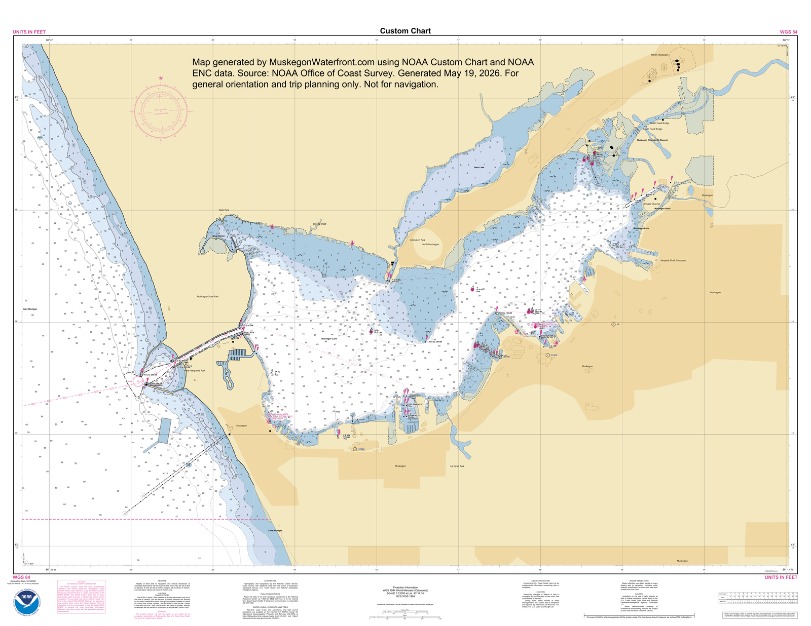
The map above is sized to fit your screen. To read the individual depth numbers clearly, open the full-size version and pinch or zoom in, or download it to view on your device.
Map generated by MuskegonWaterfront.com using NOAA Custom Chart and NOAA ENC data. Source: NOAA Office of Coast Survey. Generated May 19, 2026. For general orientation and trip planning only. Not for navigation.
Coverage Area
The chart covers the local boating area around Muskegon Lake, Bear Lake North Muskegon, the channel between them, and Muskegon Harbor. It puts what a Muskegon Lake nautical chart and a Muskegon Harbor depth map would each show into one view of the connected water system, without digging through multiple chart tools.
Depth is only one part of understanding Bear Lake. For algae, phosphorus, Phoslock treatment, stormwater, and lake-board monitoring context, read the Bear Lake water quality guide.
The chart also includes the harbor entrance around the Muskegon South Pierhead Light and breakwater arms, plus part of the Lake Michigan water depth beyond the lights. Locally, many people call those breakwaters the arms.
The map is most helpful for orientation: seeing how shorelines, channels, and depth contours fit together. It should not be treated as a promise of current water level, bridge clearance, bottom condition, marina access, dock depth, or safe passage at any specific location.
How to Use It
- Before a trip, get the general layout of both lakes and the harbor in your head.
- Compare deeper and shallower areas at a broad level before checking current conditions with official navigation sources.
- Keep it open as a visual reference while reading other boating, marina, or waterfront-access pages, such as the Muskegon Lake marinas and boat launches guide.
- The NOAA source attribution and generation date tell you where the chart data came from and when this map image was created.
Local Fishing Context
When Lake Michigan is too rough, some charter boats stay inside Muskegon Lake and fish deeper water near the SS Milwaukee Clipper on the Muskegon side. Salmon can hold in that deeper water during their runs, which is one reason the depth contours inside the harbor and lake matter.
Important Limitations
A depth map is a reference, not a substitute for current navigation judgment. Water levels change. Shoaling can occur, channels can shift, and local hazards may not be obvious from a static image. Wind, weather, season, and maintenance work all affect conditions on the two lakes and in the harbor.
Before relying on any route, confirm current conditions with official sources, marked aids to navigation, marina or harbor guidance where relevant, and what you observe on the water. Treat this map as a planning aid only.
Common Questions
How deep is Muskegon Lake?
On the NOAA-based chart shown here, the broad shallows spread along Muskegon Lake's north shore, the open middle mostly reads 35 to 50 feet, and the deepest sounding, about 78 feet, sits in the south-central basin. Bear Lake next door mostly reads 6 to 9 feet on this chart, though the chart misses its deep spots - GVSU/AWRI's direct measurements find three deeper holes at the west end, the deepest about 25 feet. Zoom the map above to read individual depths.
Can I use this Muskegon Lake and Bear Lake water depth map for navigation?
No. Use it for general orientation and trip planning only. It should not be your sole source for navigation or safety decisions.
Does the map show both Muskegon Lake and Bear Lake depth?
Yes. The chart covers depth readings for Muskegon Lake and for Bear Lake, plus the shoreline and channel context around Muskegon Harbor that connects the two.
Is there a Muskegon Lake depth chart I can view or download?
Yes. The map on this page is a NOAA-based depth chart image: view it full size or download it free with the buttons under the map, and zoom in to read the soundings for Muskegon Lake, Bear Lake, and the harbor.
Where does the depth-map data come from?
MuskegonWaterfront.com built the map from NOAA Custom Chart and NOAA ENC data published by the NOAA Office of Coast Survey.
Source and Use Disclaimer
Map generated by MuskegonWaterfront.com using NOAA Custom Chart and NOAA ENC data. Source: NOAA Office of Coast Survey. Generated May 19, 2026. For general orientation and trip planning only. Not for navigation.
Related Local Guides
Muskegon Lake Living Guide
For broader context on the lake, channel access, seasons, marinas, and local waterfront tradeoffs.
Area GuideBear Lake Guide
For local context on Bear Lake, the channel, summer use, and how the smaller lake fits the area.
Water QualityBear Lake Water Quality Guide
For algae, phosphorus, Phoslock treatment, stormwater, and lake-improvement context around Bear Lake.
Lake ConditionsMuskegon Lake Live Camera
Use the live view of Muskegon Lake as a current conditions check alongside this static depth-map reference.
FishingMuskegon Lake Fishing Guide
Put the depth contours to work; species, seasons, and public access points for Muskegon Lake.